►FEATURES
√ Download Beautiful & detailed Hardware/GPU accelerated vector charts (text stays upright on rotation)
√ Query details of Maritime object (Buoy, Lights, Obstruction etc).
√ Custom depth(Ft/Fathom/Meter) & distance units (km/mi/NM)
√ Custom Shallow Depth.
√ Record tracks, Autofollow with real-time track overlay & predicted path vector.
√ Voice Prompts for marine navigation (requires GPS )
√ 1ft / 3ft depth contour maps for anglers for selected lake maps. Useful for fishing/trolling(freshwater/saltwater).
√ Supports GPX/KML for boating route editing/import.
√ Tide & Currents.
√ Seamless chart quilting. Map details from Coastal, Approaches,Harbour, Inland Encs(rivers), and general ENC (Electronic Marine Charts) are automatically mapped to correct zoomlevel
√ Enter / import Waypoints.
► MAPS
Get all the details that you find in your chartplotters!
The maps include coverage of coast of Faroe Islands(derived from GST/KMS data).
►ROUTE MANAGEMENT / TRIP PLANNING
√ Create New /Edit Routes
√ Reverse Routes
√ Enter,Move, Add, Delete, Rename Waypoints
√ Import GPX, KML & KMZ files
√ Plot/Edit Routes
√ Share/Export Routes, Tracks & Markers
►GPS FEATURES
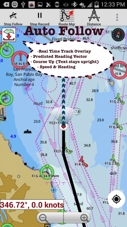
√ Auto Follow
* Real Time Track Overlay
* Predicted Path Vector
* Course Up (Text stays upright)
* Speed & Heading
√ Route Assistance With Voice Prompts
* Prompts when approaching a boating route marker
* Continous distance & ETA updates
* Alerts when sailing/boating off route
* Alerts when boating in wrong direction
√ Record Tracks
►TIDE & CURRENTS
* For US, Canada, UK,Germany&New Zealand
* High/Low Tides
* Tidal Current Prediction
* Active Current Stations
►CHARTS INCLUDED
√Faroe Islands Vestmannasund
√Funningsfjørdur
√Klaksvík
√Waters Around The Faroe Islands
√Vágsfjørður
√Faroe Islands - Soervaag Fjord
√Faroe Islands Southern Part
√Faroe Islands Northeastern Part
√Faroe Islands - Midvaag
√Faroe Islands Stroemmen
√Faroe Islands Northwestern Part
√Sandsvágur
√Faroe Islands Sundene
√Skálafjørdur
√Trongisvágur
√Nólsoyarfjørður
► SHARING
* Share tracks/routes/markers on Facebook & Twitter
* Export tracks/routes/markers as compressed GPX files.
►Instrumentation
√ Marine AIS & (NMEA AIS and GPS over TCP/UDP)
√ Wind direction & Speed,Sonar depth,Water temperature
► Change background to Satellite Imagery
We do not host i-Boating:Faroe Islands Marine on our servers. We did not scan it for viruses, adware, spyware or other type of malware. This app is hosted by Google and passed their terms and conditions to be listed there. We recommend caution when installing it.
The Google Play link for i-Boating:Faroe Islands Marine is provided to you by apps112.com without any warranties, representations or guarantees of any kind, so access it at your own risk.
If you have questions regarding this particular app contact the publisher directly. For questions about the functionalities of apps112.com contact us.

|
| ||||
| Downloads: 3 | ||||
| Updated At: 2024-04-19 23:15:00 | ||||
| Publisher: Gps Nautical Charts | ||||
| Operating System: Android | ||||
| License Type: Free Trial |